Longitude
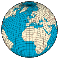
Longitude ( / ˈ l ɒ n dʒ ɪ tj uː d / , AU and UK also / ˈ l ɒ ŋ ɡ ɪ -/ ), [1] [2] is a geographic coordinate that specifies the east – west position of a point on the Earth 's surface. It is an angular measurement, usually expressed in degrees and denoted by the Greek letter lambda (λ). Meridians (lines running from pole to pole) connect points with the same longitude. By convention, one of these, the Prime Meridian , which passes through the Royal Observatory, Greenwich , England, was allocated the position of 0° longitude. The longitude of other places is measured as the angle east or west from the Prime Meridian, ranging from 0° at the Prime Meridian to +180° eastward and −180° westward. Specifically, it is the angle between a plane through the Prime Meridian and a plane through both poles and the location in question. (This forms a right-handed coordinate system with the z -axis (right hand thumb) pointing from the Earth's center toward the North Pole and the x -axis (right hand index finger) extending from the Earth's center through the Equator at the Prime Meridian.)
Page Revisions
| Year | Metadata | Sections | Top Words | First Paragraph |
| 2018 |
148604 characters 9 sections 31 paragraphs 19 images 497 internal links 17 external links |
2. Noting and calculating longitude 3. Plate movement and longitude 4. Length of a degree of longitude |
meridian 0.363 longitude 0.328 plane 0.188 equator 0.145 greenwich 0.144 pole 0.143 prime 0.132 rotation 0.130 longitudes 0.114 point 0.111 vertical 0.110 position 0.108 east 0.105 degree 0.101 length 0.099 |
Longitude ( / ˈ l ɒ n dʒ ɪ tj uː d / , AU and UK also / ˈ l ɒ ŋ ɡ ɪ -/ ), [1] [2] is a geographic coordinate that specifies the east – west position of a point on the Earth 's surface. It is an angular measurement, usually expressed in degrees and denoted by the Greek letter lambda (λ). Meridians (lines running from pole to pole) connect points with the same longitude. By convention, one of these, the Prime Meridian , which passes through the Royal Observatory, Greenwich , England, was allocated the position of 0° longitude. The longitude of other places is measured as the angle east or west from the Prime Meridian, ranging from 0° at the Prime Meridian to +180° eastward and −180° westward. Specifically, it is the angle between a plane through the Prime Meridian and a plane through both poles and the location in question. (This forms a right-handed coordinate system with the z -axis (right hand thumb) pointing from the Earth's center toward the North Pole and the x -axis (right hand index finger) extending from the Earth's center through the Equator at the Prime Meridian.) |
| 2017 |
143950 characters 9 sections 31 paragraphs 17 images 488 internal links 17 external links |
2. Noting and calculating longitude 3. Plate movement and longitude 4. Length of a degree of longitude |
meridian 0.351 longitude 0.326 plane 0.191 pole 0.167 equator 0.148 greenwich 0.146 prime 0.134 rotation 0.132 longitudes 0.116 point 0.113 vertical 0.112 position 0.110 east 0.107 degree 0.103 chronometer 0.100 |
Longitude ( / ˈ l ɒ n dʒ ɪ tj uː d / or / ˈ l ɒ n dʒ ɪ t uː d / , Australian and British also / ˈ l ɒ ŋ ɡ ɪ tj uː d / ), [1] [2] is a geographic coordinate that specifies the east - west position of a point on the Earth's surface. It is an angular measurement, usually expressed in degrees and denoted by the Greek letter lambda (λ). Meridians (lines running from the North Pole to the South Pole ) connect points with the same longitude. By convention, one of these, the Prime Meridian , which passes through the Royal Observatory, Greenwich , England, was allocated the position of zero degrees longitude. The longitude of other places is measured as the angle east or west from the Prime Meridian, ranging from 0° at the Prime Meridian to +180° eastward and −180° westward. Specifically, it is the angle between a plane containing the Prime Meridian and a plane containing the North Pole, South Pole and the location in question. (This forms a right-handed coordinate system with the z axis (right hand thumb) pointing from the Earth's center toward the North Pole and the x axis (right hand index finger) extending from Earth's center through the equator at the Prime Meridian.) |
| 2016 |
144119 characters 9 sections 31 paragraphs 17 images 486 internal links 17 external links |
2. Noting and calculating longitude 3. Plate movement and longitude 4. Length of a degree of longitude |
meridian 0.349 longitude 0.324 plane 0.190 pole 0.166 equator 0.147 greenwich 0.146 prime 0.133 rotation 0.131 longitudes 0.116 point 0.112 vertical 0.112 position 0.109 east 0.106 degree 0.103 chronometer 0.099 |
Longitude ( / ˈ l ɒ n dʒ [invalid input: 'ɨ'] tj uː d / or / ˈ l ɒ n dʒ [invalid input: 'ɨ'] t uː d / , Australian and British also / ˈ l ɒ ŋ ɡ [invalid input: 'ɨ'] tj uː d / ), [1] [2] is a geographic coordinate that specifies the east-west position of a point on the Earth's surface. It is an angular measurement, usually expressed in degrees and denoted by the Greek letter lambda (λ). Meridians (lines running from the North Pole to the South Pole ) connect points with the same longitude. By convention, one of these, the Prime Meridian , which passes through the Royal Observatory, Greenwich , England, was allocated the position of zero degrees longitude. The longitude of other places is measured as the angle east or west from the Prime Meridian, ranging from 0° at the Prime Meridian to +180° eastward and −180° westward. Specifically, it is the angle between a plane containing the Prime Meridian and a plane containing the North Pole, South Pole and the location in question. (This forms a right-handed coordinate system with the z axis (right hand thumb) pointing from the Earth's center toward the North Pole and the x axis (right hand index finger) extending from Earth's center through the equator at the Prime Meridian.) |
| 2015 |
117200 characters 9 sections 30 paragraphs 16 images 413 internal links 16 external links |
2. Noting and calculating longitude 3. Plate movement and longitude 4. Length of a degree of longitude |
meridian 0.360 longitude 0.318 plane 0.196 pole 0.160 greenwich 0.150 prime 0.137 rotation 0.135 longitudes 0.119 vertical 0.115 position 0.113 point 0.108 equator 0.108 chronometer 0.102 east 0.101 angle 0.096 |
Longitude ( / ˈ l ɒ n dʒ [invalid input: 'ɨ'] tj uː d / or / ˈ l ɒ n dʒ [invalid input: 'ɨ'] t uː d / , British also / ˈ l ɒ ŋ ɡ [invalid input: 'ɨ'] tj uː d / ), [1] is a geographic coordinate that specifies the east-west position of a point on the Earth's surface. It is an angular measurement, usually expressed in degrees and denoted by the Greek letter lambda (λ). Points with the same longitude lie in lines running from the North Pole to the South Pole . By convention, one of these, the Prime Meridian , which passes through the Royal Observatory, Greenwich , England, was intended to establish the position of zero degrees longitude. The longitude of other places was to be measured as the angle east or west from the Prime Meridian, ranging from 0° at the Prime Meridian to +180° eastward and −180° westward. Specifically, it is the angle between a plane containing the Prime Meridian and a plane containing the North Pole, South Pole and the location in question. (This forms a right-handed coordinate system with the z axis (right hand thumb) pointing from the Earth's center toward the North Pole and the x axis (right hand index finger) extending from Earth's center through the equator at the Prime Meridian.) |
| 2014 |
122954 characters 10 sections 35 paragraphs 17 images 428 internal links 15 external links |
2. Noting and calculating longitude 3. Plate movement and longitude 4. Length of a degree of longitude 5. Ecliptic latitude and longitude |
longitude 0.314 meridian 0.296 plane 0.247 equinox 0.215 ecliptic 0.213 celestial 0.183 pole 0.160 equator 0.142 greenwich 0.123 latitude 0.119 longitudes 0.114 prime 0.113 rotation 0.111 position 0.102 circle 0.101 |
Longitude ( / ˈ l ɒ n dʒ [invalid input: 'ɨ'] tj uː d / or / ˈ l ɒ n dʒ [invalid input: 'ɨ'] t uː d / , British also / ˈ l ɒ ŋ ɡ [invalid input: 'ɨ'] tj uː d / ), [1] is a geographic coordinate that specifies the east-west position of a point on the Earth's surface. It is an angular measurement, usually expressed in degrees and denoted by the Greek letter lambda (λ). Points with the same longitude lie in lines running from the North Pole to the South Pole . By convention, one of these, the Prime Meridian , which passes through the Royal Observatory, Greenwich , England, was intended to establish the position of zero degrees longitude. The longitude of other places was to be measured as the angle east or west from the Prime Meridian, ranging from 0° at the Prime Meridian to +180° eastward and −180° westward. Specifically, it is the angle between a plane containing the Prime Meridian and a plane containing the North Pole, South Pole and the location in question. (This forms a right-handed coordinate system with the z axis (right hand thumb) pointing from the Earth's center toward the North Pole and the x axis (right hand index finger) extending from Earth's center through the equator at the Prime Meridian.) |
| 2013 |
112852 characters 10 sections 35 paragraphs 16 images 399 internal links 15 external links |
2. Noting and calculating longitude 3. Plate movement and longitude 4. Length of a degree of longitude 5. Ecliptic latitude and longitude |
longitude 0.308 meridian 0.297 plane 0.247 equinox 0.216 ecliptic 0.213 celestial 0.183 pole 0.160 equator 0.143 greenwich 0.124 latitude 0.119 longitudes 0.114 prime 0.113 rotation 0.111 position 0.102 circle 0.101 |
Longitude ( / ˈ l ɒ n dʒ [invalid input: 'ɨ'] tj uː d / or / ˈ l ɒ n dʒ [invalid input: 'ɨ'] t uː d / , British also / ˈ l ɒ ŋ ɡ [invalid input: 'ɨ'] tj uː d / ), [1] is a geographic coordinate that specifies the east-west position of a point on the Earth's surface. It is an angular measurement, usually expressed in degrees and denoted by the Greek letter lambda (λ). Points with the same longitude lie in lines running from the North Pole to the South Pole . By convention, one of these, the Prime Meridian , which passes through the Royal Observatory, Greenwich , England, was intended to establish the position of zero degrees longitude. The longitude of other places was to be measured as the angle east or west from the Prime Meridian, ranging from 0° at the Prime Meridian to +180° eastward and −180° westward. Specifically, it is the angle between a plane containing the Prime Meridian and a plane containing the North Pole, South Pole and the location in question. (This forms a right-handed coordinate system with the z axis (right hand thumb) pointing from the Earth's center toward the North Pole and the x axis (right hand index finger) extending from Earth's center through the equator at the Prime Meridian.) |
| 2012 |
109798 characters 10 sections 34 paragraphs 16 images 400 internal links 14 external links |
2. Noting and calculating longitude 3. Plate movement and longitude 4. Length of a degree of longitude 5. Ecliptic latitude and longitude |
longitude 0.309 meridian 0.297 plane 0.237 equinox 0.216 ecliptic 0.214 celestial 0.184 pole 0.151 equator 0.143 latitude 0.126 greenwich 0.124 longitudes 0.115 prime 0.113 rotation 0.112 position 0.103 vertical 0.095 |
Longitude ( / [invalid input: 'icon'] ˈ l ɒ n dʒ [invalid input: 'ɨ'] tj uː d / or / ˈ l ɒ ŋ ɡ [invalid input: 'ɨ'] tj uː d / ), [1] is a geographic coordinate that specifies the east-west position of a point on the Earth's surface. It is an angular measurement, usually expressed in degrees and denoted by the Greek letter lambda (λ). Points with the same longitude lie in lines running from the North Pole to the South Pole . By convention, one of these, the Prime Meridian , which passes through the Royal Observatory, Greenwich , England, establishes the position of zero degrees longitude. The longitude of other places is measured as an angle east or west from the Prime Meridian, ranging from 0° at the Prime Meridian to +180° eastward and −180° westward. Specifically, it is the angle between a plane containing the Prime Meridian and a plane containing the North Pole, South Pole and the location in question. This forms a right-handed coordinate system with the z axis (right hand thumb) pointing from the Earth's center toward the North Pole and the x axis (right hand index finger) extending from Earth's center through the equator at the Prime Meridian. |
| 2011 |
107622 characters 10 sections 35 paragraphs 15 images 398 internal links 11 external links |
2. Noting and calculating longitude 3. Plate movement and longitude 4. Length of a degree of longitude 5. Ecliptic latitude and longitude |
longitude 0.321 meridian 0.311 plane 0.236 equinox 0.216 ecliptic 0.213 celestial 0.183 pole 0.151 equator 0.143 prime 0.124 greenwich 0.124 longitudes 0.114 rotation 0.111 latitude 0.107 position 0.102 east 0.096 |
Longitude ( / [invalid input: 'icon'] ˈ l ɒ n dʒ [invalid input: 'ɨ'] tj uː d / or / ˈ l ɒ ŋ ɡ [invalid input: 'ɨ'] tj uː d / ) [1] is a geographic coordinate that specifies the east-west position of a point on the Earth's surface. It is an angular measurement, usually expressed in degrees, minutes and seconds , and denoted by the Greek letter lambda (λ). |
| 2010 |
134428 characters 11 sections 35 paragraphs 14 images 405 internal links 12 external links |
2. Noting and calculating longitude 3. Plate movement and longitude 6. Ecliptic latitude and longitude |
meridian 0.304 displaystyle 0.282 longitude 0.269 equinox 0.192 curvature 0.192 ecliptic 0.190 equator 0.175 radius 0.170 celestial 0.163 plane 0.163 scriptstyle 0.134 ellipsoids 0.107 latitude 0.106 longitudes 0.102 pole 0.101 |
Longitude is the angular distance of a point's meridian from the Prime (Greenwich) Meridian. It is usually expressed in degrees, minutes, and seconds. Lines of longitude are often referred to as meridians ( pronounced /ˈlɒndʒɨtjuːd/ (deprecated template) or /ˈlɒŋɡɨtjuːd/ ), [1] identified by the Greek letter lambda (λ), is the geographic coordinate most commonly used in cartography and global navigation for east-west measurement. Constant longitude is represented by lines running from north to south. The line of longitude ( meridian ) that passes through the Royal Observatory, Greenwich , in England, establishes the meaning of zero degrees of longitude, or the Prime Meridian . Any other longitude is identified by the east-west angle, referenced to the center of the Earth as vertex, between the intersections with the Equator of the meridian through the location in question and the Prime Meridian. A location's position along a meridian is given by its latitude , which is identified by the north-south angle between the local vertical and the plane of the Equator. |
| 2009 |
128613 characters 10 sections 34 paragraphs 14 images 393 internal links 12 external links |
2. Noting and calculating longitude 3. Plate movement and longitude 6. Ecliptic latitude and longitude |
displaystyle 0.265 meridian 0.264 longitude 0.258 curvature 0.221 equinox 0.202 ecliptic 0.199 radius 0.178 equator 0.175 celestial 0.172 plane 0.171 scriptstyle 0.141 ellipsoids 0.113 rotation 0.104 equatorial 0.103 latitude 0.101 |
Longitude ( pronounced /ˈlɒndʒɨtjuːd/ (deprecated template) or /ˈlɒŋɡɨtjuːd/ ), [1] identified by the Greek letter lambda (λ), is the geographic coordinate most commonly used in cartography and global navigation for east-west measurement. The line of longitude ( meridian ) that passes through the Royal Observatory, Greenwich , in England, establishes the meaning of zero degrees of longitude, or the prime meridian . Any other longitude is identified by the east-west angle, referenced to the center of the Earth as vertex, between the intersections with the equator of the meridian through the location in question and the prime meridian. A location's position along a meridian is given by its latitude , which is identified by the north-south angle between the local vertical and the plane of the equator. |
| 2008 |
126818 characters 10 sections 28 paragraphs 14 images 398 internal links 15 external links |
2. Noting and calculating longitude 3. Plate movement and longitude 6. Ecliptic latitude and longitude |
displaystyle 0.302 curvature 0.252 meridian 0.237 equinox 0.230 radius 0.203 longitude 0.203 ecliptic 0.170 scriptstyle 0.160 ellipsoids 0.128 plane 0.126 rotation 0.119 equatorial 0.117 equator 0.114 pole 0.110 ε 0.107 |
Longitude ( Template:IPAEng or Template:IPAEng [1] ), symbolized by the Greek character lambda (λ), is the geographic coordinate most commonly used in cartography and global navigation for east-west measurement. A line of longitude is a north-south meridian and half of a great circle . |
| 2007 |
43254 characters 8 sections 21 paragraphs 2 images 109 internal links 12 external links |
2. Noting and calculating longitude 4. Ecliptic latitude and longitude |
curvature 0.309 meridian 0.291 equinox 0.282 radius 0.249 ecliptic 0.209 longitude 0.197 equatorial 0.158 ellipsoid 0.151 rotation 0.146 plane 0.140 longitudes 0.128 ellipsoids 0.126 east 0.109 celestial 0.103 degree 0.100 |
Longitude is the east-west geographic coordinate measurement most commonly used in cartography and global navigation. |
| 2006 |
31879 characters 9 sections 20 paragraphs 2 images 112 internal links 8 external links |
1. History of the measurement of longitude 2. Ecliptic latitude and longitude |
longitude 0.311 equinox 0.311 meridian 0.278 ecliptic 0.230 harrison 0.163 rotation 0.160 longitudes 0.141 circle 0.125 time 0.122 chronometer 0.121 111 0.116 celestial 0.113 pole 0.109 ellipsoids 0.104 decimal 0.098 |
Longitude , sometimes denoted by the Greek letter λ (lambda) , [1] [2] describes the location of a place on Earth east or west of a north-south line called the Prime Meridian . Longitude is given as an angular measurement ranging from 0° at the Prime Meridian to +180° eastward and −180° westward. Unlike latitude , which has the equator as a natural starting position, there is no natural starting position for longitude. Therefore, a reference meridian had to be chosen. While British cartographers had long used the Greenwich meridian in London , other references were used elsewhere, including: El Hierro , Rome , Copenhagen , Jerusalem , Saint Petersburg , Pisa , Paris , Philadelphia and Washington . In 1884 , the International Meridian Conference adopted the Greenwich meridian as the universal prime meridian or zero point of longitude . |
| 2005 |
25636 characters 8 sections 19 paragraphs 1 images 101 internal links 5 external links |
1. History of the measurement of longitude 2. Ecliptic latitude and longitude |
equinox 0.329 longitude 0.310 meridian 0.271 ecliptic 0.244 rotation 0.170 longitudes 0.150 harrison 0.138 circle 0.132 celestial 0.120 ellipsoids 0.110 decimal 0.103 stars 0.101 positively 0.101 pole 0.101 position 0.099 |
Longitude , sometimes denoted by the Greek letter λ , describes the location of a place on Earth east or west of a north-south line called the Prime Meridian . Longitude is given as an angular measurement ranging from 0° at the Prime Meridian to +180° eastward and −180° westward. Unlike latitude , which has the equator as a natural starting position, there is no natural starting position for longitude. Therefore, a reference meridian had to be chosen. While British cartographers had long used the Greenwich meridian in London , other references were used elsewhere, including: Ferro , Rome , Copenhagen , Jerusalem , Saint Petersburg , Pisa , Paris , Philadelphia and Washington . In 1884 , the International Meridian Conference adopted the Greenwich meridian as the universal prime meridian or zero point of longitude . |
| 2004 |
8514 characters 2 sections 6 paragraphs 1 images 44 internal links 3 external links |
meridian 0.430 longitude 0.285 genius 0.225 111 0.220 person 0.191 universal 0.176 greenwich 0.149 measurement 0.135 utc 0.128 hours 0.127 prime 0.123 degree 0.118 hour 0.113 ferro 0.113 starting 0.110 |
Longitude , sometimes denoted λ, describes the location of a place on Earth east or west of a north-south line called the Prime Meridian . Longitude is given as an angular measurement ranging from 0° at the Prime Meridian to plus or minus 180°. Unlike latitude , which has the equator as a natural starting position, there is no natural starting position for longitude. Therefore, a reference meridian had to be chosen. While British cartographers had long used the Greenwich meridian in London , England , other references were used elsewhere, including: Ferro , Rome , Copenhagen , Jerusalem , Saint Petersburg , Pisa , Paris , and Philadelphia . In 1884 , the International Meridian Conference adopted the Greenwich meridian as the universal prime meridian. |
|
| 2003 |
4964 characters 1 sections 4 paragraphs 0 images 34 internal links 0 external links |
meridian 0.504 genius 0.264 person 0.223 longitude 0.223 universal 0.206 greenwich 0.175 utc 0.150 hours 0.148 prime 0.144 hour 0.133 360 0.127 circle 0.122 chronometer 0.119 petersburg 0.119 pisa 0.119 |
|
|
| 2002 |
3286 characters 0 sections 5 paragraphs 0 images 17 internal links 0 external links |
genius 0.335 meridian 0.319 person 0.283 utc 0.254 longitude 0.247 hours 0.188 prime 0.182 hour 0.168 starting 0.164 360 0.161 circle 0.155 chronometer 0.151 lone 0.151 position 0.150 measurement 0.134 |
Longitude describes the location of a place east or west of a north-south line called the prime meridian . Longitude is given in an angular measurement ranging from 0° at the Prime Meridian to plus or minus 180°. Unlike latitude which has the equator as a natural starting position, there is no natural starting position for longitude. Therefore an arbitrary starting position was chosen that passed through Greenwich in London, England. |
|
| 2001 |
1916 characters 0 sections 3 paragraphs 0 images 9 internal links 0 external links |
genius 0.540 meridian 0.257 lone 0.244 measurement 0.216 harrison 0.196 prime 0.196 minus 0.186 greenwich 0.179 solved 0.179 longitude 0.171 overview 0.154 prize 0.145 england 0.143 london 0.143 historical 0.136 |
Longitude describes the location of a place east or west of a north-south line called the prime meridian . Longitude is an angular measurement ranging from 0° at the prime meridian to plus or minus 180°. Zero degrees is defined as a point which passes through Greenwich in London, England. |